

THE TRIDENT PROPERTY · MOUNT PLEASANT
Ten homes.
What changes?
The proposal, the impacts, and the questions worth asking.
Get the one-minute overview ↓THE ONE-MINUTE VERSION
Here’s the proposal.
Ten detached home lots behind Trident Academy, with a new street from Wakendaw Road ending in a cul-de-sac.
The sketch includes a pond, green space, buffers, and walking paths. The school remains shown on a separate parcel. [2]
Awaiting sketch-plan review. This is a layout proposal; engineering and home approvals would follow. [3]
A BETTER SENSE OF THE PLACE
Your neighborhood.
Before & after.
Compare the existing grass soccer field and play area with an illustrative buildout.
 AFTER AI ILLUSTRATIONBEFORE GRASS FIELD & PLAY AREA
See the sketch & other views+
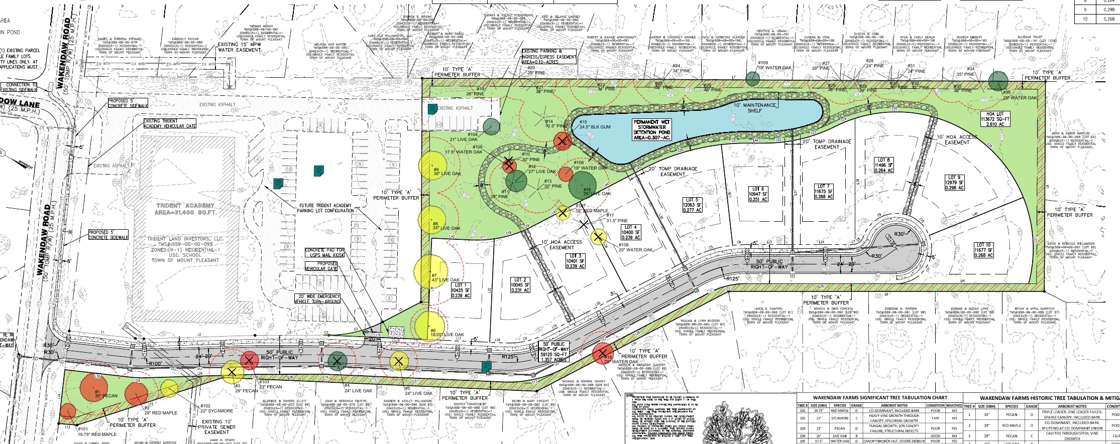 APPLICANT DRAWING · SEPT 23, 2026
One new road enters from Wakendaw Road and ends in a cul-de-sac. The existing school is on a separate parcel.
WHAT IT COULD MEAN FOR US
Three things to watch.
Tap a topic for the key question to ask.
Traffic & safe accessNew trips could overlap with school traffic.+
The entrance matters for drivers, walkers, and cyclists. The reviewed materials do not establish how queues or delay would change.
Show school-day traffic counts, turning visibility, safe crossings, and the construction-truck route.
Drainage & gradingA pond is proposed. Its performance needs proof.+
Roads, roofs, and grading could change runoff. Final grades, drainage calculations, outfalls, and downstream capacity need to show how neighbors will be protected.

Where will water go during heavy rain, and what calculations demonstrate no harmful effect on neighboring property?
Trees & constructionSome tree loss and temporary disruption are likely.+
The applicant’s protected-tree inventory shows 11 removals and 33 retained. It counts surveyed trees at least 16 inches in diameter, not every tree or total canopy. Staff identify a good-condition live oak among the removals. [3]
Clearing and building could bring noise, dust, and truck traffic. The sketch package reviewed has no construction schedule or truck-route commitment.
Can more trees be saved, and what protections will cover screening, school hours, erosion, and construction access?
IF YOU WANT TO GO DEEPER
A few more answers.
Home prices, designs & property values +
No home elevations, prices, or builder commitments were found in the posted package reviewed. The effect on existing home values is unknown; the evidence does not support a percentage gain or loss.
Would these homes join Wakendaw Lakes? +
Shared street access does not establish association membership. “HOA area” on the drawing does not establish WLCA ownership or costs. Confirm the governing documents and permanent maintenance agreements. [2]
What about recreation or new amenities? +
The plan includes green space and a path, with a public-use note. It does not propose a pool or tennis courts. Different recreational uses would require an agreement with the owner, a feasible plan, and funding. Public access and maintenance commitments still need confirmation. [2]
Lot sizes, buffers & technical details +
Proposed lots: about 10,045–12,979 sq ft each. The drawing shows a 50-foot public road right-of-way, a 10-foot Type A perimeter buffer, a 5-foot sidewalk, and an 8-foot plantation-mix path. [2]
Land allocation: 2.574 acres in home lots; 1.357 in new road right-of-way; 2.610 in HOA area. The HOA area includes green space, buffers, the pond, and an existing access easement. Rounded totals differ by 0.001 acre.
Items for staff: reconcile conflicting side-setback figures, resolve overflow parking in green space, and explain consistency between R-1 zoning and the staff map’s Community Facilities future-land-use designation. [2] [3]
Keep following review: current code describes a 15-day appeal period after preliminary-plat approval, and separate opportunities for engineering comments. Confirm the applicable dates and procedures with the Town. [5] [14]
Open full drawing & package ↗HAVE YOUR SAY
Bring a clear question.
Mount Pleasant Town Hall
100 Ann Edwards Lane
Reference SP-13-26 · Wakendaw Road
The agenda lists October 16 for correspondence. Confirm submission timing or late comments with Planning staff.
Make a short question list +
Choose the questions you want to raise.
FOLLOW THE EVIDENCESources & supporting recordsOpen drawings, reports, code, and historical records.+
No matching sources.
About this guide
Research is dated October 16, 2026. Project facts come from the agenda, application, staff exhibits, and public records. Resident discussion helped identify questions; it does not establish project facts.
AI-generated visuals illustrate possible scale or general concepts. Home designs, planting, exact geometry, and drainage details in those images are imagined. The applicant’s drawing and Town records govern the proposal.
This guide does not include a field survey, traffic study, drainage model, title search, or independent flood determination. Documents missing from the sketch package may exist elsewhere in the Town’s file.